


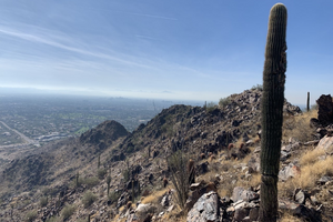
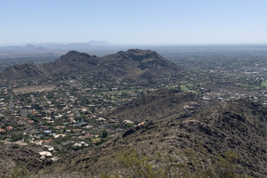
Camelback Mountain (via Echo Canyon Trail)
4925 E. MCDONALD DR., PHOENIX, AZ 85018
2.5 miles
Out and back
1420 ft elevation gain
Difficulty: hard
Estimated time to complete: about 2 hours
A beautiful hike up one of the most popular mountains in Arizona, this route is heavily trafficked and open all year round. Make sure to pack your hats, sunscreen, and tons of water because this one is a doozy! Considered a Point of Pride, Camelback is one of Phoenix’s most prominent landmarks and its unique “camelback” shape can be recognized from various viewpoints across the city. Please leave your furry friends at home, but bring your human friends as you scale and climb the mountain and make your way to the top to catch views of Scottsdale and Phoenix!
Piestewa Peak
5594 E. Squaw Peak Dr., Phoenix, AZ 85016
2.1 miles
Out and back
1148 ft elevation gain
Difficulty: hard
Estimated time to complete: about an hour and 40 mins
A heavily trafficked trail with some of the most beautiful views in the valley, the Piestewa Summit Trail makes it easy to capture that photo-worthy moment. This trail has a lot of rocks and is mostly uphill, so visitors should be up for the challenge! Dogs are not allowed on this trail, but there are others not too far where you can bring Fido. Another Phoenix Point of Pride as part of the Phoenix Mountains Preserve, Piestewa is known for its breathtaking views overlooking the Valley of the Sun.
Lookout Mountain
15600 N. 16th St., Phoenix, AZ 85022
Circumference: 2.2 miles / Summit: .9 miles
Circumference: Loop / Summit: Out and back
Circumference: 275 ft / Summit: 469 ft elevation gain
Difficulty: moderate
Estimated time to complete:
Circumference: about an hour and 10 mins / Summit: about 45 mins
This gorgeous scenic hike is known for its title – lookout mountain – where you can look out over exquisite desert views as you either make your way to the top on the summit trail or complete the circumference trail. Depending on the time, visitors may find a crowded trail as this is a popular one that’s open to dogs on leashes, children, hikers, runners, and walkers, but it will be worth it for a moderate to easy hike.
Quartz Ridge
6511 E. Sierra Vista Dr., Phoenix, AZ 85018
3.2 miles
Out and back
623 elevation gain
Difficulty: moderate
Estimated time to complete: about an hour and 45 mins
 If you’re looking for a nice summit trail with gorgeous Phoenix Mountains Preserve views that you can bring your dog to (unlike Camelback and Piestewa), then this is the hike for you! This moderately challenging hike allows dogs and mountain biking, and you’ll see plenty of hikers and trail runners along the way, too. Once you get out past the switchbacks, the trail connects to other potential hikes that can take you to different areas of the vast desert.
Mormon Loop to National Trail Loop
8610 S. 24th St., Phoenix, AZ 85042
4.7 miles
Loop
1167 ft elevation gain
Difficulty: moderate
Estimated time to complete: about two hours and 45 mins
If you love never-ending desert scenery in addition to city views, then look no further than this combo hike! This moderately difficult South Mountain (a Phoenix Point of Pride) trail will take you to some of the most stunning parts of the dessert, but keep in mind that there is little shade; it is often crowded; and it is a popular mountain biking trail – so go early if you want to beat the crowds and the heat!
Pinnacle Peak
26802 N.102nd Way, Scottsdale, AZ 85262
4 miles
Out and back
1033 ft elevation gain
Difficulty: moderate
Estimated time to complete: about two hours and 19 mins
While not a true peak trail, this hike is definitely one to add to the list. It crosses through the mountainous, rocky region and overlooks a golf course in addition to some beautiful homes and desert views. Keep in mind that this is a very touristy trail, so there will probably be large groups of people during peak times/seasons – because of this, though, there are some incredible places to stop, sit, and take in the sights along the way. While dogs are not allowed at Pinnacle Peak, there are signs telling you other hikes nearby where you can bring your furry friends. These are other trails throughout the Valley that allow dogs, as well.
Tom’s Thumb
23015 N. 128th St., Scottsdale, AZ 85255
4 miles
Out and back
1236 elevation gain
Difficulty: hard
Estimated time to complete: about two and a half hours
Tom’s Thumb is many Arizona hikers’ favorite, but definitely prepare yourself for a tough challenge. This trail is dog friendly, but they might be pulling you up the mountain with their leash for the first half before things even out. Once you get to the “thumb”, you are in for a treat of incredible McDowell Sonoran Preserve views that seem to go on forever. It does get a bit windy at parts, so prepare yourself!
Apache Wash
1600 E. Sonoran Desert Dr., Phoenix, AZ 85085
2.8 miles
Loop
1334 ft elevation gain
Difficulty: easy
Estimated time to complete: about an hour and 15 mins
Exceedingly popular with mountain bikers, hikers, and trail runners, Apache Wash Loop Trail is a part of the Phoenix Sonoran Desert Preserve and countless people go exploring out there to take in some of the pure beauty. Considered an easy trail, people can enjoy the seemingly endless desert views year-round to take in the wildflowers, cactus, and nature preserve.
Hole in the Rock
625 N. Galvin Pkwy., Phoenix, AZ 85008
.3 miles
Out and back
32 ft elevation gain
Difficulty: easy
Estimated time to complete: about 10 mins
A Point of Pride in Phoenix, this hike is more of a walk/short climb and there is one main reason people come: to see the hole in the rock! A very crowded site located in Papago Park, this trail is kid and dog friendly and can be visited any time of year. Only the brave attempt to climb up the rock, while others grab their photo of the hole and sit to relax for a bit while taking in the views.
40th St. Trailhead (LV Yates to Two Bit/Dixie Peak Loop)
9200 N. 40th St., Phoenix, AZ 85028
2.7 miles
Loop
859 ft elevation gain
Difficulty: moderate
Estimated time to complete: an hour and 40 mins
Entering the Phoenix Mountains Preserve at 40th Street, this hike is considered moderate and relatively easy despite its rocky nature. This loop trail starts off on Trail #8 (LV Yates) and continues up Dixie Peak, also known as Two Bit Peak. You will not regret choosing this hike as it is a less intense way to get similar views as Camelback and Piestewa.
This post has been contributed by a third party. The opinions, facts and any media content are presented solely by the author, and JewishPhoenix assumes no responsibility for them. MORE


 - 2023-04-03T161839.615")


 - 2024-03-25T085519.472")

 (9)")


 (5)")

 (1)")
")

 (1)")


 - 2024-04-16T132329.807")

 (9)")


 - 2024-04-15T092022.719")
 - 2024-04-15T085938.177")


 - 2023-01-18T102702.116")


